


If you're an avid hiker, then Utah is on your rader—it's filled with enough natural wonders and incredible trails to impress almost any hiker. From picturesque waterfalls to winding slot canyons and natural sandstone arches, these are the best places to hike in and around stunning Grand Staircase Escalante National Monument.
As I pulled into yet another scenic overlook on The All-American Road: Scenic Byway 12, I realized that getting to Utah's Grand Staircase Escalante National Monument might take longer than Google Maps had suggested. After all, it didn’t take into account my multiple stops as I tried to fit this sprawling majesty into an Instragram-worthy picture. Eventually, I gave up on staring at it through my phone and stood there, awe-struck by the cliffs striped by ochre, vermillion, and taupe—each one dotted with specks of dark green trees. I peered into the distance as the road twisted like a discarded black ribbon, and wondered what incredible hiking trails lay just out of sight.
Scenic Byway 12 spans 124 miles (200 kilometers) and travels through some of the most rugged and isolated parts of Utah. It's the premiere destination for a Utah road trip—it travels by Bryce Canyon and Capitol Reef National Parks; Kodachrome Basin, Anasazi, and Escalante Petrified Forest State Parks; Glen Canyon National Recreation Area; and Dixie National Forest. On my journey from Denver, I bypassed the always-popular Moab area, with its access to Canyonlands and Arches—perennial favorites with the Colorado crowds—and I’m so glad I did. I stopped to peek at petroglyphs and shot more ineffective photos of the grandeur of Capitol Reef National Park. But my ultimate destination was a hiking trip in Escalante.
Though the area is huge at one million acres (it would take weeks to explore even a good hunk of it), I based myself in Escalante city. This is ideal for anyone seeking the best hikes in the area given the several trailheads within a short drive. In the shoulder season of late March, this area was downright sleepy, so I plotted out a number of hiking trails of increasing difficulty. I would start with a mellow first-morning hike to Lower Calf Creek Falls before hiking to some more challenging slot canyons. If you’re headed to the area, these are some of the best hikes.
Best Hikes in Escalante
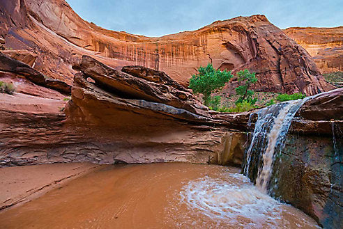
Lower Calf Creek Falls (Easy)
A great warm-up hike or one ideal for beginner hikers, the trail to Lower Calf Creek Falls is located about 15 miles east of Escalante. Covered in sand, the six-mile out-and-back path is mellow and winds through canyons striped with shades of umber, sienna, and red ochre. Grab a brochure for the guided walk at the start and the pamphlet details where you can find spots known for beaver activity and sight the petroglyphs carved on the walls. Your destination is a 126-foot waterfall that, unlike most in Utah, cascades all year. Embrace the solitude then head back.
Lower Calf Creek Falls hiking tips: Stock a small daypack with your hiking essentials: a raincoat, sunscreen, snacks, plenty of water, and a first aid kit. Even if it’s an “easy” hike, being prepared is key. A $5 fee is charged per vehicle for parking at the trailhead.
Peek-A-Boo and Spooky Slot Canyons (Easy to Moderate)
Half of the adventure is getting to the start of these two hikes, a journey that takes you 26 miles down the unpaved, bumpy Hole-in-the-Rock Road, the start of which is located just a few miles outside Escalante at Dry Fork Wash. Head down the short cliffs, following the cairns, and you’ll find the entrance to Peek-A-Boo.
Even though they are only three miles long, conquering both of these slot canyons as a loop (which I highly recommend) will take you three to four hours, depending on your skill level and how often you stop to wonder how you exactly you got in there. You don’t need any technical skills, but going at it solo requires more skill and fortitude than I had. Luckily, I met a nice brother-sister duo at the head of the hiking trail so I had company and a hand up at times.
Start at Peek-A-Boo, a slot and corkscrew canyon. Scramble up the rock wall (there are “handholds” there, but having a friend or two is super helpful, as are good, grippy shoes) and make your way into the canyon. The sandstone waves, curls, and twists, creating an adult jungle gym that at times makes this Escalante hike feel more like parkour.
At the end of Peek-A-Boo, don’t miss Spooky Gulch, which is just a short hike away. This narrow slot canyon was more fun to me: It required some body contortion to get through the canyon and at one point my two new friends and I were situated in some interesting poses to let another group get through. It’s not a good place for claustrophobes or larger adults (NFL linebackers would have a really hard time here), but you’ll feel like a rock star when you emerge back into startling sunlight.
Peek-a-Boo and Spooky Slot hiking tips: Think a money belt is only for international travel? Think again. A belt like this is great for keeping your hiking essentials safe when you’re tossing your pack through canyons. My companion almost lost her car keys in the soft sand of the slot—this would have kept them super safe.
Coyote Gulch (Moderate to Difficult)
This 11.5-mile round trip hike through a long, somewhat narrow canyon can be done in a day, but if you have the time and the camping gear, most people choose to spend the night. Though Coyote Gulch is a strenuous hike that requires some serious rock scrambling, it’s not considered technical. I would not recommend attempting this hike solo, but if you can tackle Coyote Gulch with a crew you’ll be rewarded with views of natural arches, like Stevens Arch and Coyote Natural Bridge.
Coyote Gulch hiking tip: If you’re camping or backpacking overnight, be sure to use your packing cubes to keep wet bathing suits or inadvertently wet and smelly clothes separate from your clean(ish) gear.
Additional Escalante Hiking Trails
- Escalante Natural Bridge: This is an easy introductory hike of just 2-3 hours. Start at the Escalante River trailhead and plan to see arches, petroglyphs, and more.
- Golden Cathedral: If you've seen an Instagram shot of a Escalante hike, it was probably this one. It's a difficult and long hike, however, so be very prepared for a long hiking day before undertaking its 10 miles (16 kilometers).
- Willis Creek Narrows and Slot Canyon: See an entirely different slot canyon on this easy out-and-back hike that takes up to three hours. Avoid this hike in late summer as there is a risk of flash flooding.
- The Cosmic Ashtray: Not for the faint of heart, this difficult hike has an elevation gain of 1,900 feet (580 meters). You'll need to ask your guesthouse or campsite for help planning a route near this amazing geological formation as there is no designated trail to follow.
- Zebra Slot Canyon: An easy-to-moderate is best hiked after a dry spell. And expect water on the hike no matter—enough that most hikers carry their shoes for a time.
- Devil’s Garden: This is a hike as pretty as it is easy at just a mile long. You could easily make this a first hike or a final goodbye to the area.
Escalante, UT Hiking Tips
- Escalante Yurts offers incredible glamping yurts—it's a great way to immerse in this spectacular area.
- Pace yourself! There are many hikes of various levels of difficulty and it's best to plan enough time in the area that you can partake in some easy warm up hikes before trying any of the more difficult hiking trails.
- Follow the Leave No Trace principles. That means always stay on the trail, never carve into the rocks (a picture is proof enough you were there!), and bring a backpack or waist pack large enough to carry all of your food for the day, and to carry your waste back out.
- Bring sun protection as you can't guarantee shade on any hike—that means a hat, sunblock, and sunglasses.
- Always carry enough food and water—you're planning to hike in the desert!
- Always notify your hotel or campsite of your hiking plan for the day. Don't expect cell phone service as many trailheads around Escalante are in remote areas.
- Download the GPS route of your hike to your phone for any of the more difficult hikes (and even the easy ones!).
Ready to head out? Here's what you should know about desert hiking.
While Eagle Creek is here to provide tips and insights on travel, we cannot accept any responsibility for any potential consequences arising from the use of this information. Always conduct your own research and use your best judgment.
Related Links (from Eagle Creek blog):
Why You Should Visit U.S. National Parks in the Offseason
Best Southwest US Road Trip Route
Adventure for One: Solo Travel in the American Southwest


