


There’s nothing like the beauty of Colorado—it’s full of natural wonders with topographical variety, from unique rock formations and dunes to peaks soaring over 14,000 feet in the air. These are Colorado’s most iconic hikes and hiking trails, including essential details and best insider tips.
Signs proclaiming “Welcome to Colorful Colorado” line the state’s borders, greeting visitors with a promise of adventure. From north to south and east to west, Colorado is home to some of the country’s most diverse topography, from sand dunes to hoodoos, stunning mountain peaks reflected in mountain lakes surrounded by wildflowers to 14ers that are popular destinations for ‘peak baggers.’
As with any of the best hikes in Colorado, an early morning start is highly recommended—afternoon thunderstorms are an almost daily occurrence in the summer months and conditions can quickly become dangerous on even the most common hiking trails. Dress for the worst case scenario, pack extra clothing, and be ready to shelter overnight if needed. Your daypack should include sunscreen, bandages, cell phone or satellite phone, and extra food (pack more than you think you’ll need). Water is key to acclimating to Colorado’s high altitude and dry climate. Think safety first when hiking anywhere—always let someone know where and when you’re hiking and be realistic about your ability level.
As someone born and raised in Colorado, here’s a list of the state’s five most iconic hikes—the hiking trails that are absolute must-dos for anyone visiting or living in the state—plus all the essential details my best insider tips.
1. Maroon Bells
You’ve no doubt seen images of the Maroon Bells peaks, a pair of 14ers sitting side by side with pristine Maroon Lake reflecting them at the base—they’re the most photographed mountains in North America. Just 12 miles outside of Aspen, the area offers six pet-friendly hiking trails, plus campsites and biking trails.
How to get there: Maroon Bells is accessible by bike, bus, or car, but the road is closed from mid-November to Memorial Day weekend and is only accessible at that time via cross-country, hike, ski, or snowmobile. During peak visitation season, car access is restricted and you must pay $10. The area is a known hot-spot for avalanches, so use the Maroon Bells hotline to check important information in the area.
When to hike: Summer is the busiest time and the parking lot fills quickly, so buses or bikes are recommended and if possible, visit mid-week to avoid crowds. In fall, mid-September is when the aspen trees are in full color.
Best hiking trails and sights: The peaks are epic destinations for sunrise or sunset, an easy stroll with a picnic, or a more challenging adventure of Four Pass Loop. The 26-mile linkup connects four mountain passes, all over 12,000 feet, circumnavigating Maroon Bells and offering views of lush alpine valleys filled with wildflowers. Both East Maroon (15 miles) and West Maroon (12 miles) connect hikers to the town of Crested Butte. The trail is challenging and takes 6-8 hours. East Maroon is easier and features views of Emerald Lake, Copper Lake, and Pyramid Peak. West Maroon is steeper but has incredible views from the top of the pass. Hikers need to coordinate pickup with a local transportation company at the trailhead in Crested Butte. (Aspen’s Chamber of Commerce has up to date and detailed information about Maroon Bells and navigating transportation). Of course, folks can also take a quick hike to Crater Lake or around Maroon Lake without committing to a full day-long affair.
2. Garden of the Gods
There’s no place on earth like the Garden of the Gods—300 foot sandstone rock formations tower over hikers against a backdrop of Colorado’s legendary blue skies and Pike’s Peak. Just outside of Colorado Springs, it features several short hikes (the longest is a 3-mile loop) within the park, but there are also several other options for recreation including climbing classes, Jeep or segway excursions, and electric and standard bicycle tours. Altogether, the trails make up 21 miles of hiking trails and several of the footpaths are paved, offering wheelchair and handicapped accessibility.
Best hiking trails and sights: The Visitor & Nature Center is world-class and features a cafe and patio, plus a roster of guided hikes that run the gamut from those that are guided with a naturalist to those that include yoga, are geology-focused, or teach family outdoor skills. An easy day-trip from Denver, Garden of the Gods is a great place to spend the morning hiking, enjoy a packed or restaurant lunch, and return home. Since the distances are short and the hikes aren’t terribly challenging, you can go light on gear—a simple around-the-waist pack should do the trick. However you may want to make a weekend out of your hiking adventure: Garden of the Gods is also near several other area attractions, like Cave of the Winds, Red Rock Canyon Open Space, the Pikes Peak Cog Railway, Seven Falls, Manitou Cliff Dwellings, Manitou Springs, the Cheyenne Mountain Zoo, and the Broadmoor.
3. Sand Dunes
Covering 30 square miles, the Great Sand Dunes National Park is home to several dunes that reach over 700 feet tall—the tallest sand dunes in North America. There are no actual designated trails in the sand; visitors explore the dunes at their leisure. (There are even special sand-friendly wheelchairs at the Visitor Center.)
Best hiking trails and sights: At the base of the dunes, Medano Creek is often running and makes a great place to cool off, since afternoon temps at the dunes can be near 150 degrees Fahrenheit, and is the spot where Sandhill cranes stop during their annual migration. Once visitors summit the first dune, High Dune on First Ridge, which takes roughly an hour and is a little over a mile, a breathtaking view of the entire dunefield is the reward.
Bordering the actual dunes is the rest of the National Park, which includes grasslands, shrublands, wetlands, and alpine lakes and trails that were used by Native Americans and early settlers, who had a settlement of 20 houses in the 1800s. Part of the Sangre de Cristo mountain range, the numerous hiking trails not only offer beautiful Colorado scenery and wildlife, but an opportunity to beat the heat.
4. Quandary Peak
Colorado has the most 14ers (peaks that top 14,000 feet or more) of any state in the U.S., with a total of 58 peaks. Quandary Peak, near Breckenridge, is the most commonly climbed because it’s the easiest and most accessible for hikers (i.e. you don’t need 4WD). It’s also considered the most dangerous, not because it’s difficult, but because people underestimate their skills and there are simply so many who use the hiking trail.
Hiking tips for Quandary Peak: It takes 4 to 6 hours to climb the low-grade 6.7 mile up-and-back trail. Dogs are allowed (leashed) and expect a crowded, heavily trafficked route. It’s the highest peak in the Tenmile Range and part of the White River National Forest. Be sure to pack all the essentials you’ll need to be on the mountain all day in a sturdy daypack, and start early.
How to get there : There are two trailheads, one off of CO 9 that is easy to find but isn’t hiked as frequently because of steeper grades, and one on Blue Lakes Road (850) before a switchback leading up Hoosier Pass. There are two parking lots and it is well marked, but if parking on the road, do it along McCullough Gulch Road 851, as 850 is populated with homes whose driveways could be blocked. In the summer the trail is easy to find and well marked, however, during the winter months it can be hard to spot through the snow pack (you may want to strap some spikes on)—take a right by the bug boulder .03 miles in. The trail switchbacks up the mountain, eventually the summit is visible and the hiking trail is more or less straight up. The majority of this hike is above treeline, so there isn’t a lot to see as far as flowers and trees go, but the trail is heavily populated by friendly marmots that are used to people, and lots of mountain goats. The mountain goats are attracted to the salt in urine and sweaty clothes, and they can get aggressive (a 350 pound male fatally gored a hiker in Washington) so they are to be avoided.
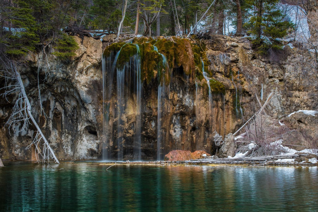
5. Hanging Lake
Just outside of Glenwood Springs, Hanging Lake is in beautiful Glenwood Canyon and part of the White River National Forest. It’s a steep, rocky, and rigorous 1.2 mile backcountry hike. The view at the top is spectacular: Wispy waterfalls flow from the canyon wall into an emerald green lake, surrounded by lush greenery.
Hiking tips for Hanging Lake: It was declared a National Natural Landmark in 2011, but because it is so popular (bordering on overuse), permits are required year-round to access the trail. During peak months (May 1st to October 31st), visitors need to buy tickets to the trail in advance (there are time slots), park at the Visitor's Center, and take the shuttle. During the off-peak season, visitors can park at the Hanging Lake lot, but permits are still required and are frequently checked by rangers. Hanging Lake is accessible from the 9.5 mile Glenwood Canyon Recreation Path by bike or hike (you still need a permit).
Hiking in nature is good for the spirit—to make it good for the planet, be sure to geotag responsibly , leave no trace behind, and choose sustainable gear .
Related Links (from Eagle Creek blog):